
MoDOT finally wrote down the reason Gravois stays dangerous.
It’s one sentence long.

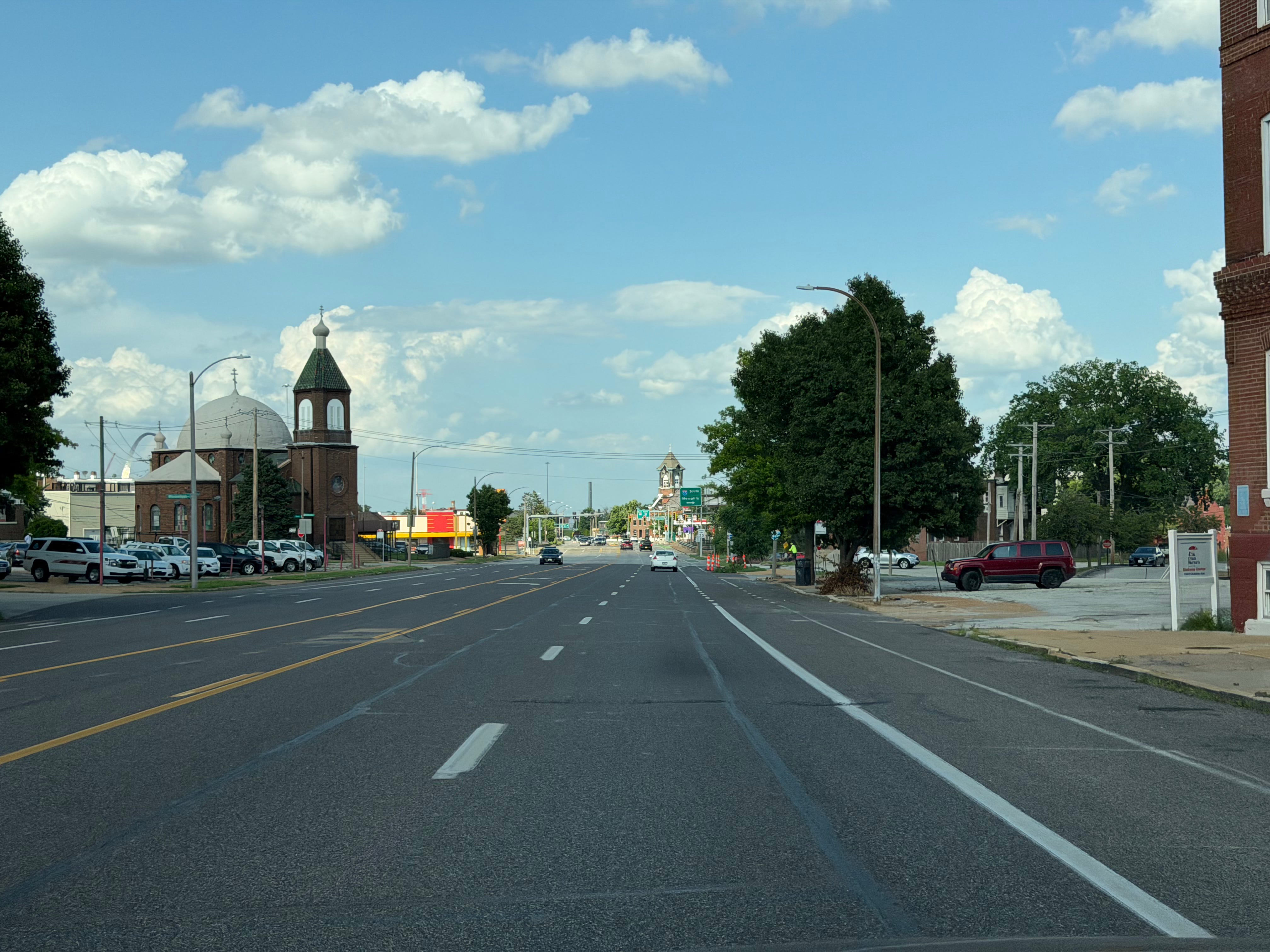
I took this photo on my drive home. I have a phone full of photos like this, taken across months, at the hours when Gravois is supposedly doing its essential work. They always look the same: an enormous gray runway with a few cars on it, and somewhere in the background a steeple from the era when this street belonged to a neighborhood.
Hold that image. Now read what MoDOT brought to this week’s open house.
The June 10 meeting was the second of four in the planning study for the 2029 Gravois project, the one that will decide what this street is for the next thirty years. Credit where due: the boards are more substantive than anything from the 2017 round. There are real proposals in there. Intersection simplification at Shenandoah, Sidney, and Delor. Access changes at ten unsignalized crossings, including 13th and Allen. Yes, that Allen, the intersection where a man was killed on May 10, three days after I published my last piece on this road. The department is, at minimum, now asking some of the questions it skipped last time.
But one board, titled “How Roadway Space Is Used,” contains the sentence that governs everything else:
“Some areas are not the best candidate for reduced vehicular lanes because of significant impacts to traffic flow.”
Read it again. That sentence is a ranking. It tells you what loses the tiebreaker every time safety and throughput point in different directions. Twenty-two people died on this road between 2020 and 2024. Eight of them were on foot. And the planning document’s organizing principle is the protection of flow.
So let’s talk about that flow. Where it came from, who it serves, and what your family pays so it can keep moving.
The traffic they’re protecting was supposed to get here seventy years ago
Here’s the part of the story nobody at the open house will tell you.
Gravois wasn’t always seven lanes. For most of its life it was a narrow street with a streetcar down the middle, lined with corner storefronts. Which is why the neighborhoods around it are a National Historic District today. The width came in the 1920s, when the city widened a whole network of avenues in anticipation of explosive growth. The city’s chief planner put the prediction in writing: St. Louis would reach 900,000 people by 1970.
The widening was not gentle. The city took twenty to thirty feet off the front of private property by eminent domain, and where buildings stood in the way, it paid to saw the fronts off and rebuild the façades on what remained. Those shortened buildings are still standing on Gravois right now. Walk the stretch between Tucker and Jefferson and you can find them - storefronts that look slightly compressed, slightly off-proportion, because a hundred years ago the city cut them back to make room for traffic that was on its way.
The traffic never came. St. Louis peaked at 856,796 people in 1950 and has lost population every decade since. When 1970 actually arrived, the census counted 622,236 — the forecast missed by 278,000. Today we’re around 278,000 total, barely a third of what the planners were building for. The gap between the prediction and the present is the size of the entire city that actually existed in 1970.
And the through-traffic the width was meant to carry? It got a better offer. I-55 opened its first downtown stretch in 1955 and cut the downtown-to-Gravois trip from fifteen minutes to five. I-44 was finished through the city in 1972. The long-haul drivers Gravois was widened for have had a free, faster, grade-separated alternative for fifty years. The state’s own regional planning agency said the quiet part in writing back in 2016: the interstates “significantly reduced the traffic volume along Gravois Road, which is now considered to be an overbuilt roadway.”
Overbuilt. Their word, a decade ago. The city segments carry roughly 10,000 to 20,300 vehicles a day, and federal guidance says streets under 20,000 are candidates for lane reduction. Exactly one stretch of Gravois in the city clears that bar, by about 300 cars.
So when MoDOT’s board warns about “significant impacts to traffic flow,” understand what’s actually being protected: lanes built for a city of 900,000 that never showed up, carrying traffic the interstates absorbed two generations ago. We sawed the fronts off people’s buildings for this flow. We’ve buried twenty-two neighbors in five years for this flow. It was never coming.
What “protecting flow” costs you, specifically
The board helpfully lists the harms that lane reduction might cause. Take them one at a time, because every one of them lands on your kitchen table, just not the way MoDOT means.
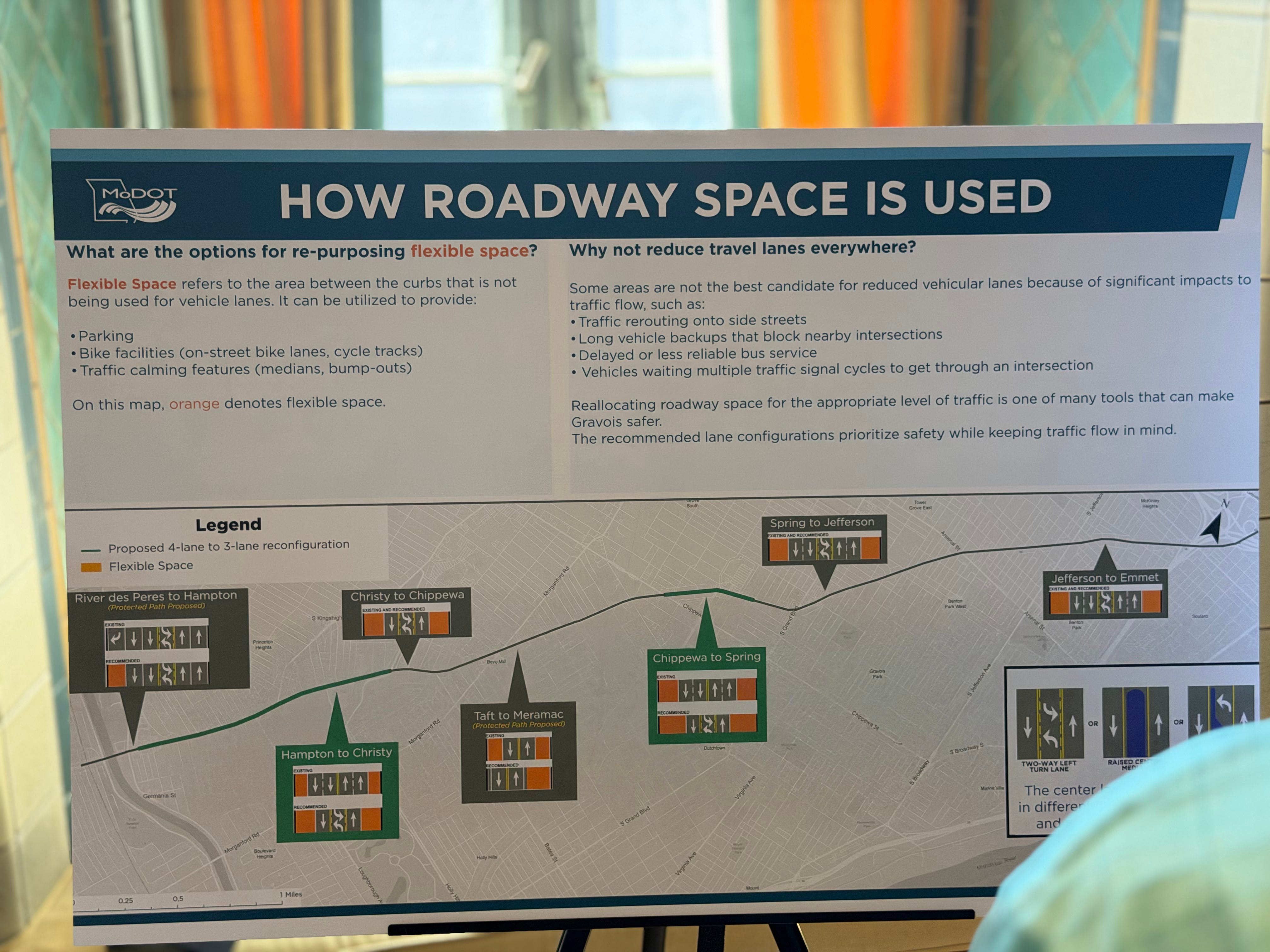
“Traffic rerouting onto side streets.” Three boards over, MoDOT proposes restricting or closing side-street access at ten intersections along this same corridor. The department is already in the business of managing side-street traffic, enthusiastically, when it serves intersection geometry. The concern only becomes disqualifying when the cause is taking lanes from cars. Cut-through is a real issue with a standard toolkit, starting with the same access treatments already on MoDOT’s boards. Solvable in design. A weak reason to veto the lane question before the study even runs.
“Delayed or less reliable bus service.” C’mon. The #10 Gravois and #11 Chippewa carry some of the highest ridership in the Metro system, and those riders are delayed today by general traffic, because the bus sits in the same lanes as every car. A lane reduction that dedicates space to transit, or adds queue jumps at signals, makes the bus faster and more reliable. Citing bus riders as the reason to preserve general-purpose car lanes is using transit passengers as a shield for the people delaying them.
“Long vehicle backups” and “vehicles waiting multiple traffic signal cycles.”Backups when? The honest engineering answer is: during the peak. Some slice of the peak hour, some days, in some segments and directions. We are sizing a street for its worst fifteen minutes and accepting its impact on the surrounding neighborhoods for the other twenty-three and a half hours as overhead. No hospital quadruples its bed count so that flu season never feels crowded. Streets are the one piece of public infrastructure where the worst-case quarter-hour gets to dictate the permanent design, and the slack is paid for in people.
And note what the board concedes in its final line: “The recommended lane configurations prioritize safety while keeping traffic flow in mind.” When safety needs an asterisk, the asterisk is the policy.
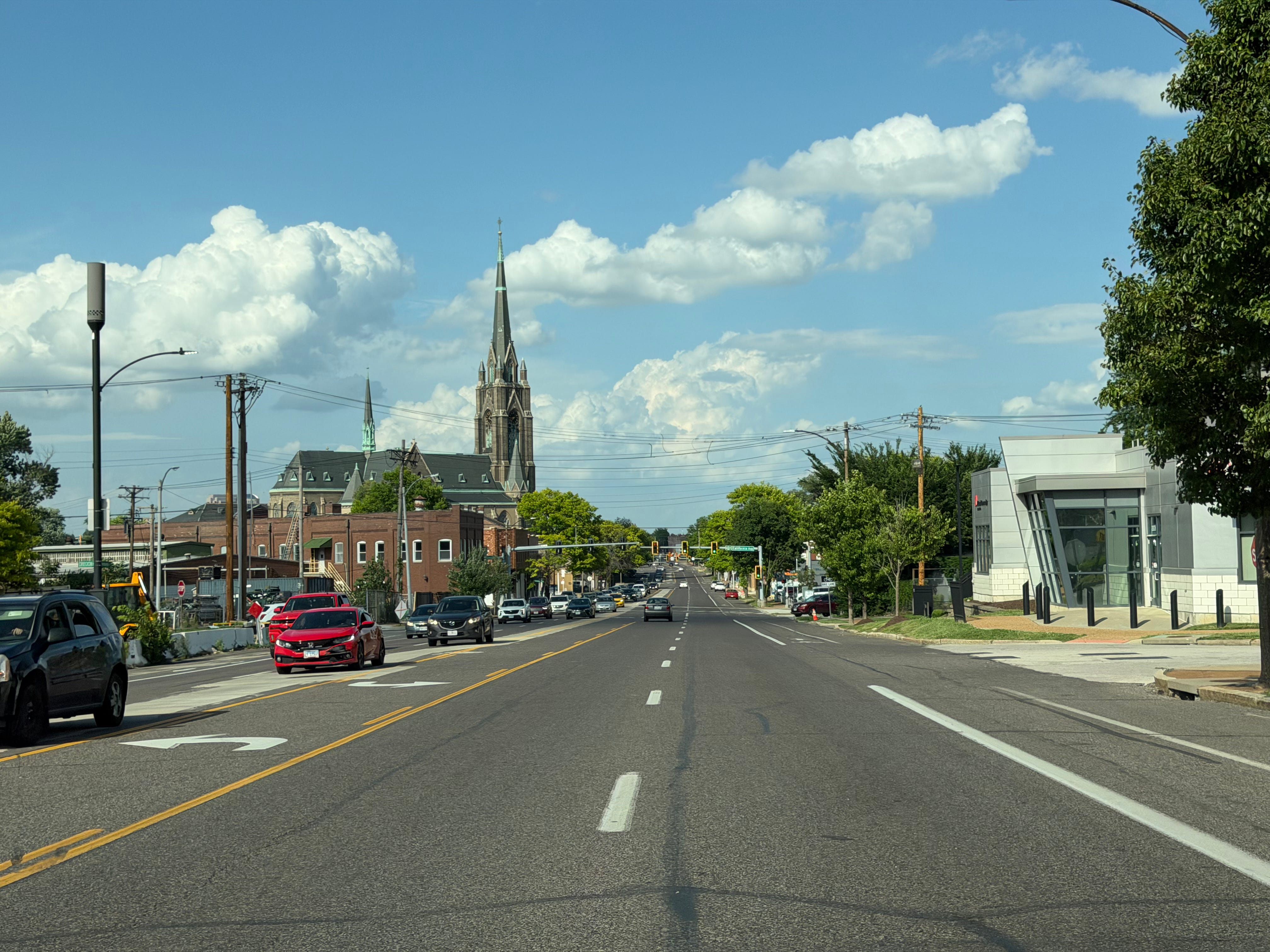
One more move on the boards deserves attention. The corridor has been sorted by “roadway typology”: segments that read as walkable Main Street are candidates for change; segments that read as auto-oriented, presumably, are not. But the auto-oriented stretches got that way because a seven-lane surface highway killed the storefronts, and the parking lots and drive-throughs that replaced them are now cited as the “context” that justifies keeping the lanes. Look at that the photo below: the St. Francis de Sales steeple, built when Gravois was a streetcar street, rising over a foreground striped like a regional airport. Historical road decisions go in, “neighborhood character” comes out, and the character ratifies the road. If typology is destiny, the wide parts of Gravois stay wide forever, for the crime of having been widened.
The question MoDOT’s numbers can’t answer
You can view all the boards down the page at this link. Every number on MoDOT’s boards is a count: how many vehicles, which movements, what delay. Counts tell you how many cars are on Gravois. The question that should decide this entire study is one a count can’t touch:
Where are those cars going?
A trip from Bevo Mill to a Benton Park restaurant is South City traffic. Gravois should serve it, and a redesigned Gravois still would. A trip from the I-44 interchange to the county line, taken on Gravois because the driver prefers it to I-55, is something else entirely. A through-trip, free-riding on a neighborhood street.
The distinction matters because of what sits half a mile east. We already built the road for through-trips. It’s called Interstate 55, it’s grade-separated, it cost a fortune, it’s also overbuilt, and we are still paying to maintain it. If a meaningful share of Gravois traffic is drivers paralleling the interstate, then the region is paying twice for the same trips: once in concrete on I-55, and once in lives and comfort on Gravois. “Significant impacts to traffic flow” translates to: we must keep a neighborhood street lethal so that drivers have a free alternative to the interstate we built for exactly this purpose.
The data to settle this exists. Origin-destination analysis from anonymized location data is routine in corridor studies; MoDOT procures it elsewhere. I’m sending MoDOT a list of fifteen questions on the record asking where the traffic actually goes, about what their own 2024 arterial framework says should govern this design, about the population assumptions behind a 2029 build.
What the city’s project can and can’t do
One of the boards at the open house belongs to the city: a quick-build traffic-calming project from Jefferson to Shenandoah, breaking ground this summer. Flashing-beacon crossings and turn restrictions, while, per the board’s own text, “maintaining existing travel lanes.”
That project will help. Beacons and islands are triage, and triage saves lives. But a city quick-build can paint a crosswalk; it cannot change the cross-section of a state-controlled highway. The lane count question - the only question with thirty-year consequences - gets decided in MoDOT’s study, and the recommendations lock at the third public meeting in November. Design follows in 2027. After that, the answers are concrete. Literally.
Between now and November, everyone with authority over this corridor owes the public a position on lane reduction where the safety analysis calls for it. MoDOT’s St. Louis District. The Mayor’s office, whose own Transportation & Mobility Plan already printed a map titled “Potential Road Diet Candidates” with Gravois on it. The Board of Aldermen, for every ward this street touches. The November meeting is the wrong place to discover where they all stand. You can file your own thoughts about this specific project here, and I greatly encourage you to share your voice.
Three asks before November
Publish the origin-destination data. Local trips versus through-trips, by segment. Volume counts without destinations are a decision pre-cooked to favor flow.
Publish the 2017 road-diet results. MoDOT restriped two sections of Gravois to fewer lanes in 2017; six-to-five from Jefferson to I-55, four-to-three from Christy to Chippewa. Those diets have run for nine years on this exact street. If lane reduction had wrecked traffic flow, that finding would be on a board in 72-point type. It isn’t. Either the data vindicates the diet, or the department never measured its own intervention. Both answers are worth hearing out loud.
Write down the trade. Somewhere in the safety analysis is an implicit exchange rate between vehicle delay and human injury. Put it on a board. If the department believes some number of seconds of motorist delay outweighs a pedestrian death, the public is entitled to see the number and to vote on the people who accept it.
A hundred years ago this city sawed the fronts off buildings to make room for traffic that never came. The buildings are still shortened. The traffic is still missing.
The study locks in November. The least it owes back is an honest sentence about what it’s optimizing for. Right now that sentence is on the board, and it’s about traffic.
Sources:
MoDOT Route 30 (Gravois) Pavement Resurfacing and Safety Improvements project page and June 10, 2026 public meeting display boards;
MoDOT corridor crash data 2020–2024;
Harland Bartholomew, Comprehensive City Plan (1947);
St. Louis Post-Dispatch archives on the 1920s–30s street widenings and the 1955 Third Street Highway opening;
Saint Louis Patina on the Gravois realignment and rebuilt façades;
East-West Gateway, Great Streets: Gravois Road Strategic Planning Report (2016);
Trailnet comment letter on the Gravois Avenue Striping and Signals Project (2016);
The Blueprint for Arterials, East-West Gateway and MoDOT (2024);
City of St. Louis Transportation & Mobility Plan (2025);
U.S. Census Bureau decennial counts and Vintage 2025 estimates;
KSDK reporting on the May 10, 2026 Gravois & Allen fatality.